News
Dubai Integrates LiDAR & Digital Twins For Road Management
The Road and Traffic Authority hopes to enhance road maintenance with faster, safer, and more accurate assessments.
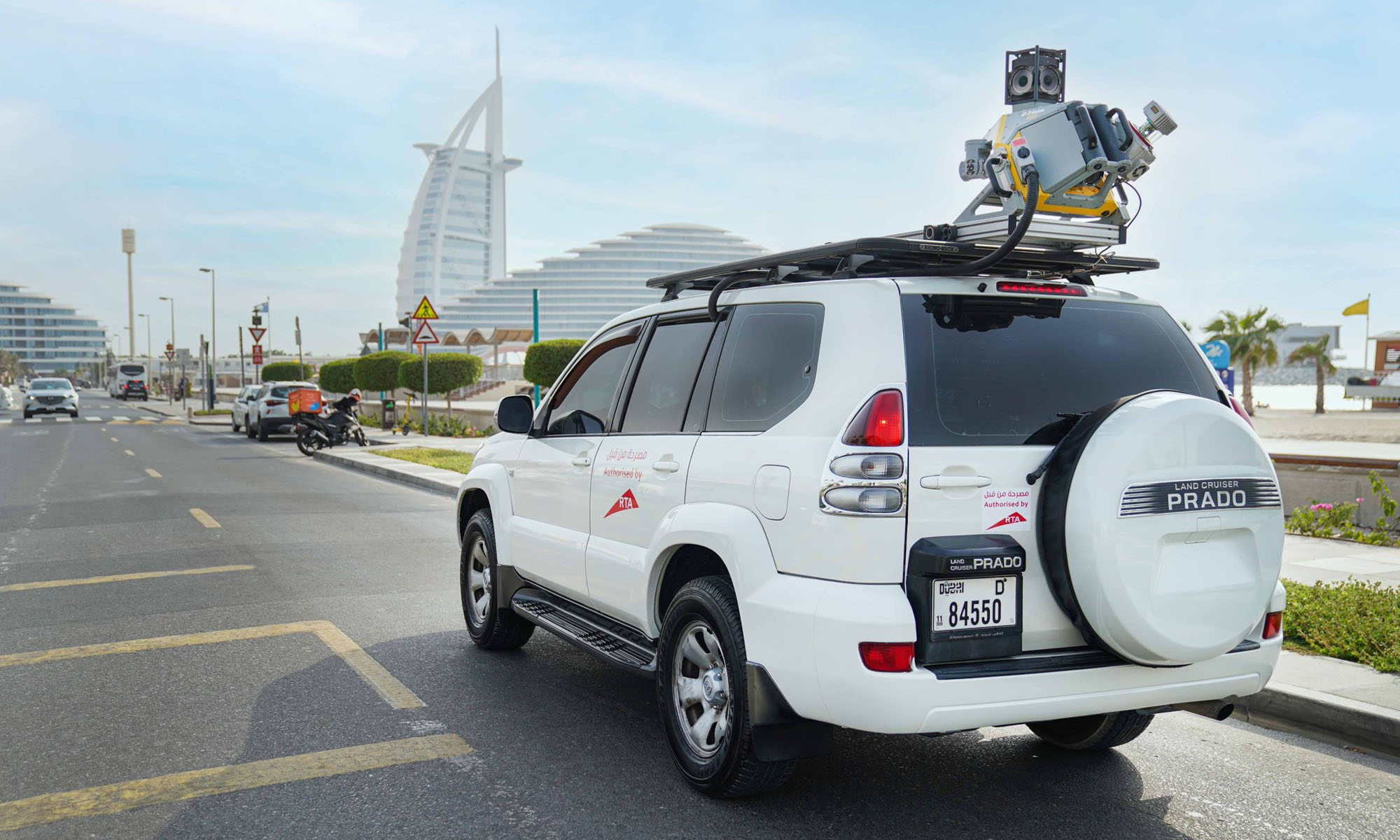
Dubai’s Roads and Transport Authority (RTA) is stepping up its road maintenance game by introducing LiDAR — short for Light Detection and Ranging — into its asset management system. This tech shift is part of a broader strategy to modernize how the city monitors and maintains its roads, using data-driven insights from digital twin platforms.
RTA has adopted the latest LiDAR (Light Detection and Ranging) technology to assess the condition of road assets and enhance the accuracy of data used in digital twin platforms. The initiative supports the development of preventive, predictive, and proactive maintenance… pic.twitter.com/8I7j9J9haw
— RTA (@rta_dubai) April 9, 2025
LiDAR isn’t new to the tech world, but RTA’s application of it marks a leap in how public infrastructure is managed. Instead of relying on slower, traditional visual inspections, lasers scan and map road conditions in real time. The result? Faster, more accurate data collection that feeds into advanced maintenance strategies — both preventive and predictive.
Hussain Al Banna, CEO of the Traffic and Roads Agency at RTA, highlighted the efficiency gains. “LiDAR technology delivers a remarkable boost in performance and speed, delivering up to 300% compared to traditional visual inspections,” he said. It’s a move that fits with Dubai’s broader vision of becoming a global model for smart, sustainable cities.
Accuracy is another key benefit. According to Al Banna, LiDAR offers up to 95% accuracy when assessing road conditions. This precision enhances the reliability of the data used for infrastructure decisions and helps streamline maintenance planning.
Also Read: Checkout.com Set To Launch Card Issuing In The UAE
LiDAR also enables safer inspections of high-up or hard-to-reach assets — think traffic lights, road signs, and lighting poles. This kind of efficiency isn’t just about numbers; it also reduces (or even eliminates) the need for manual labor in hazardous environments.
The scale of coverage is another game-changer. LiDAR will allow the RTA to scan around 80 kilometers of roads in a single day — a massive improvement compared to older methods, which typically cap out at 3 kilometers per day. Scanning can also be done on the move, at speeds between 30 and 100 km/h, helping to avoid road closures and traffic blockages.
Al Banna also emphasized the value of this real-time, high-resolution data in long-term planning: “This advanced technology delivers highly accurate data and detailed analysis of asset conditions, supporting the long-term sustainability of the Assets Condition Index (ACI)”. He noted that it helps in smart scheduling of maintenance, especially predictive tasks, by prioritizing based on strategic needs.


News
Google Releases Veo 2 AI Video Tool To MENA Users
The state-of-the-art video generation model is now available in Gemini, offering realistic AI-generated videos with better physics, motion, and detail.

Starting today, users of Gemini Advanced in the MENA region — and globally — can tap into Veo 2, Google’s next-generation video model.
Originally unveiled in 2024, Veo 2 has now been fully integrated into Gemini, supporting multiple languages including Arabic and English. The rollout now brings Google’s most advanced video AI directly into the hands of everyday users.
Veo 2 builds on the foundations of its predecessor with a more sophisticated understanding of the physical world. It’s designed to produce high-fidelity video content with cinematic detail, realistic motion, and greater visual consistency across a wide range of subjects and styles. Whether recreating natural landscapes, human interactions, or stylized environments, the model is capable of interpreting and translating written prompts into eight-second 720p videos that feel almost handcrafted.
Users can generate content directly through the Gemini platform — either via the web or mobile apps. The experience is pretty straightforward: users enter a text-based prompt, and Veo 2 returns a video in 16:9 landscape format, delivered as an MP4 file. These aren’t just generic clips — they can reflect creative, abstract, or highly specific scenarios, making the tool especially useful for content creators, marketers, or anyone experimenting with visual storytelling.
Also Read: Getting Started With Google Gemini: A Beginner’s Guide
To ensure transparency, each video is embedded with SynthID — a digital watermark developed by Google’s DeepMind. The watermark is invisible to the human eye but persists across editing, compression, and sharing. It identifies the video as AI-generated, addressing concerns around misinformation and media authenticity.
While Veo 2 is still in its early phases of public rollout, the technology is part of a broader push by Google to democratize advanced AI tools. With text-to-image, code generation, and now video creation integrated into Gemini, Google is positioning the platform as a full-spectrum creative assistant.
Access to Veo 2 starts today and will continue expanding in the coming weeks. Interested users can try it out at gemini.google.com or through the Gemini app on Android and iOS.

Google Releases Veo 2 AI Video Tool To MENA Users

PayPal & TerraPay Join Forces For Cross-Border MENA Payments

Influencer Growth Fuels Saudi Creator Economy Surge

Dubai Integrates LiDAR & Digital Twins For Road Management