News
Dubai Integrates LiDAR & Digital Twins For Road Management
The Road and Traffic Authority hopes to enhance road maintenance with faster, safer, and more accurate assessments.
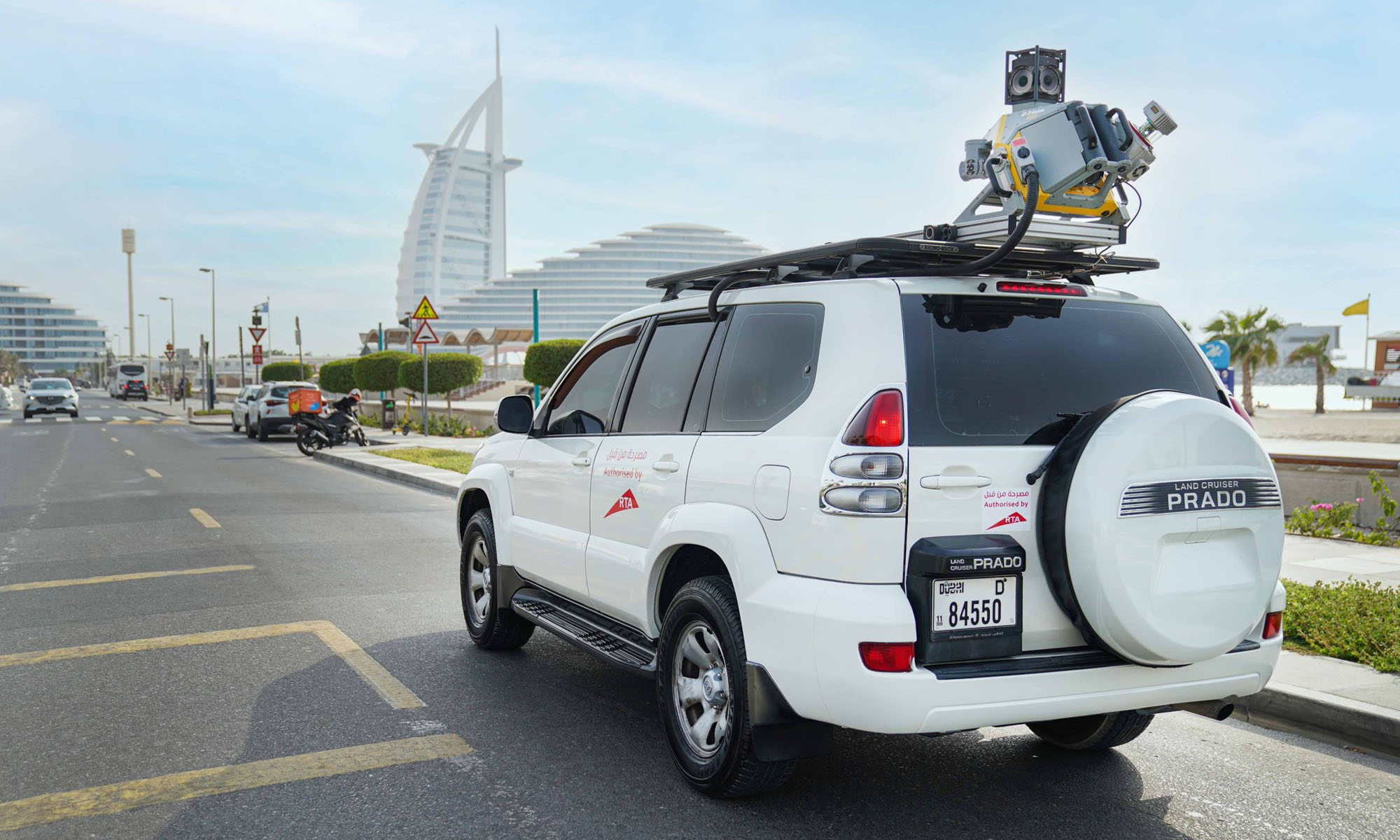
Dubai’s Roads and Transport Authority (RTA) is stepping up its road maintenance game by introducing LiDAR — short for Light Detection and Ranging — into its asset management system. This tech shift is part of a broader strategy to modernize how the city monitors and maintains its roads, using data-driven insights from digital twin platforms.
RTA has adopted the latest LiDAR (Light Detection and Ranging) technology to assess the condition of road assets and enhance the accuracy of data used in digital twin platforms. The initiative supports the development of preventive, predictive, and proactive maintenance… pic.twitter.com/8I7j9J9haw
— RTA (@rta_dubai) April 9, 2025
LiDAR isn’t new to the tech world, but RTA’s application of it marks a leap in how public infrastructure is managed. Instead of relying on slower, traditional visual inspections, lasers scan and map road conditions in real time. The result? Faster, more accurate data collection that feeds into advanced maintenance strategies — both preventive and predictive.
Hussain Al Banna, CEO of the Traffic and Roads Agency at RTA, highlighted the efficiency gains. “LiDAR technology delivers a remarkable boost in performance and speed, delivering up to 300% compared to traditional visual inspections,” he said. It’s a move that fits with Dubai’s broader vision of becoming a global model for smart, sustainable cities.
Accuracy is another key benefit. According to Al Banna, LiDAR offers up to 95% accuracy when assessing road conditions. This precision enhances the reliability of the data used for infrastructure decisions and helps streamline maintenance planning.
Also Read: Checkout.com Set To Launch Card Issuing In The UAE
LiDAR also enables safer inspections of high-up or hard-to-reach assets — think traffic lights, road signs, and lighting poles. This kind of efficiency isn’t just about numbers; it also reduces (or even eliminates) the need for manual labor in hazardous environments.
The scale of coverage is another game-changer. LiDAR will allow the RTA to scan around 80 kilometers of roads in a single day — a massive improvement compared to older methods, which typically cap out at 3 kilometers per day. Scanning can also be done on the move, at speeds between 30 and 100 km/h, helping to avoid road closures and traffic blockages.
Al Banna also emphasized the value of this real-time, high-resolution data in long-term planning: “This advanced technology delivers highly accurate data and detailed analysis of asset conditions, supporting the long-term sustainability of the Assets Condition Index (ACI)”. He noted that it helps in smart scheduling of maintenance, especially predictive tasks, by prioritizing based on strategic needs.


News
A Three-Clinic Network Bets Dubai Is Ready For Longevity Medicine
Longevium has enlisted nearly 100 clinicians and created an AI platform in a bid to sell biological-age tracking as a medicine, not a wellness service.

Dubai has been busily creating the scaffolding for a longevity industry, including a dedicated regulatory authority and a health market deep enough to sustain it. Now the clinics are arriving.
Longevium, a longevity clinic network, has opened three locations across the city: a flagship at Triple Seven Mall on Jumeirah 3, and branches in Jumeirah Lake Towers and Jumeirah Village Circle. Together they house a multidisciplinary team of nearly 100 physicians and specialists offering what the company bills as “a measurable medical system for longevity”.

The pitch is that longevity medicine should look less like a wellness menu and more like continuous clinical care. Each patient’s biological age assessment, laboratory results, body composition, cardiovascular risk factors, metabolic markers, and lifestyle data feed into a single profile, with a proprietary AI platform helping physicians track progress and adjust protocols against the patient’s own biomarkers.
“Healthy aging must be approached clinically through diagnostics, biomarkers, physician supervision, longitudinal tracking, and protocols tailored to the individual,” said Dr. Ksenia Butova, Longevium’s founder and CEO. “Our goal is to help patients understand their health trajectory before disease develops, and then actively change that trajectory”.
The treatment list spans peptide-based protocols, exosome therapies, stem cell approaches, GLP-1 metabolic optimization, hormone balance programs, cardiovascular prevention, and regenerative aesthetics — a model built for the entrepreneurs, executives, and international patients the clinic says want measurable results rather than generic wellness. A signature offering, Longevity Day, compresses biomarker testing, ultrasound and vascular imaging, specialist consultations, IV therapy, and a personalized optimization roadmap into a single three-hour visit.
Also Read: Dubai Certifies The World’s First Purpose-Built Air Taxi Vertiport
“Here, longevity, biotechnology, AI, prevention, and regenerative medicine are converging into a single ecosystem,” said Butova. “This is why Longevium was built in Dubai, and why we believe the UAE can become a global reference point for longevity medicine”.
The emirate established the Dubai Longevity Authority in 2026 to oversee its longevity, wellness, and advanced health sectors, and the Dubai Health Authority reported insured beneficiaries exceeding 4.9 million in 2025, up around 6.5%, with insurance claims reaching approximately 49.6 million, up around 13.5%.

A Three-Clinic Network Bets Dubai Is Ready For Longevity Medicine

YouTube Rolls Out Supervised Children’s Accounts Across MENA

Meta’s New AI Tool Builds Images From Public Instagram Photos

Tamper With The Recording LED & Meta’s Glasses Kill Camera

Samsung’s Next Unpacked Could Bring Two Galaxy Z Fold 8 Models

LUVED Is A New Curated Preloved Marketplace For The UAE

Can AI Save Your Relationship? This New “Wingman” App Thinks It Can

WhatsApp Usernames Are Coming: Here’s How To Claim Yours

Dubai Certifies The World’s First Purpose-Built Air Taxi Vertiport

OpenAI Cleared To Launch GPT-5.6 Publicly After Government Review


-

 News2 months ago
DJI Teases Dual-Camera Osmo Pocket 4P For 2026 Launch
-

 Web32 months ago
2026 Crypto Trends: Bitcoin, ETFs & The Future Of Payments
-

 News2 months ago
Lebanon Ministers Meet Visa Over National Digital Payment Platform
-

 News2 months ago
At I/O 2026, Sundar Pichai Concedes AI Must Deliver Real Value